We wished that we had had with us the Florida Trail data book, since we had hiked 50 miles of this same stretch the year before, and there were a few places we wanted to try to find again, but we were working from memory and from a different perspective, so we didn't find them all. But for anyone thinking about canoeing or hiking this stretch, it would definitely be useful. (I'm lookin at you, Annie!)
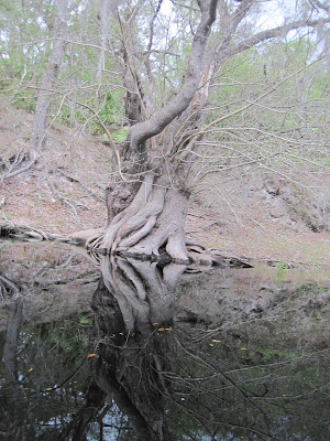
The reflections on the Suwannee are just stunning. The trees, the limestone cliffs, the sky. Beauty:
There were SO MANY of these trees on the banks, especially in the first half of the trip. They were huge, bulbous, gnarly, and often split strait through in their bases, and then they would spread and thin out about 6 feet up. I need to find out what they are...
Baby Alligators! We saw several 3-5 footers as well, but these guys were only about a foot and a half long.
The first night we camped on a tiny sandbar island in the middle of the river, a few miles upstream of Big Shoals. It was nice, but everything got lots of condensation on it, not to mention sand. Should have taken a photo... Alas...
The next day we reached Big Shoals early in the day, and as we stopped at the launch a mile before the rapids to refill our water, we met a couple who were just doing a day paddle, but we quickly found many connections between us. They were in Florida because they hiked the entire Florida Trail this winter, and before they left the state on the way back home (Portland, Oregon), on the tail end of a year long travel, a friend suggested they do a day paddle around Big Shoals. They were dropping in as we stopped at the launch. They had met Rachel Renne on the Trail, who if you do not know her is a New College alum, and a truly wonderful human being. We talked a bit about Florida, the trail, and then about the Pacific Crest Trail, which these two (Goodness and Zim, together they are Team Color) had through hiked last summer, and Mike through-hiked the summer before. It was nice to meet and talk with them, and to obviously have a lot in common. Maybe we'll see you again someday....
Big Shoals is the only class 3 rapids in Florida. We, however, did not go over them. We had lots of gear and instead we portaged around them. The guys in the picture below were camped right on the banks of the shoals, and were raising their arms in triumph after passing over the last big bump, and then promptly overturned their canoe. Mike and I had a good time laughing and heckling from the shore with their friends, who were more experienced than they were, and watched as it took them about 8 minutes to get back into their canoe, and then finally paddle back to the near shore through the current.
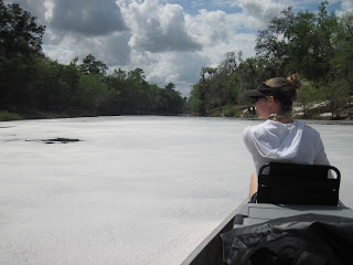
The foam from the shoals lasted for a LONG time afterwards. This was at its thickest, just after launching after the shoals:
Cypress knees are crazy and wonderful:
Which of these two is right side up?
Passing through White Springs around sunset:
The namesake of White Springs was a mineral spring with a bathing house built around it. Now, the river just flows into the hole, and the flow is reversed, but the bath house structure is still there:
Look at the photo on the top right of this informational sign, with the line of people - Mike was amazed that 'the pimp pose' is older than hip hop :-P
The second night we camped a few miles past White Springs and Stephen Foster Folk Center. This time we set up camp on a high, shaded cliff above the north side of the river, just off the Florida Trail, in a dried up depression/water drainage bed. I wouldn't call it a creek, but if it were raining, it sure would be where all the water went before going into the river.
A little ways down the next day, where Swift Creek joins the river, we found this crazy scaly lizard that we have yet to identify:
So many tree swings everywhere! Also, beautiful green foliage.
This line of oaks looked to stately and regal to me:
We tried fishing repeatedly, but we only had one type of lure and didn't have much luck finding fresh bait, so we didn't catch anything. But just before sunset on that third day, we met a man who calls himself Teddy Bear and is a local celebrity chef in White Springs (here's an article in the local paper about him). He was standing on a steep bank 20 feet above the water, with his young granddaughter, fishing for cat fish. He hadn't had any luck that day, but had stories to tell of catfish so heavy that he couldn't haul them up the cliff. (It was obviously his favorite fishing hole.) We talked with him for a few minutes, and Mike and I were both struck at his kind, youthful nature, that smile shining constantly. He gave us some chicken livers to try our hand at catfishing, but we didn't end up having the opportunity. After we left and said goodbye, Mike almost instantly regretted not having stayed and talked with him longer. He was quite a character, and it would have been good to hear more of his stories. We have hopes of meeting him again.... and hey, it's possible, now that we know where his fishing spot is :)
This was a really cool place. We got there right around sunset, so this photo is dark, but it gives you the gist of the place. It's Suwannee Springs, another old natural spring turned natural bathhouse touted for its mineral waters' healing qualities. This photo was taken from the top of a tall, rough stone wall overlooking the sight. On the right, you can see a middle-height tier covered with grasses, and then the beach in the middle, complete with a small tree just by the far wall. There was something I found so alluring and magical about this place. Maybe it had to do with the twilight, or the man-made structure cradling this natural place, and being slowly reclaimed by the water and the plants. But this is somewhere I will come back to:
We ended up paddling into the dark that night, and camping on the beach of Spirit of the Suwannee Music Park. We could hear Del McCoury playing for miles before we got there, and Mike was somewhere between delighted and heartbroken that we heard Vincent 1952 Black Lightning, one of his favorite songs. We had played with the idea of paying for a day ticket to Springfest, either for Friday night or for Saturday, but in the end, we weren't quite ready to leave the relative calm and solitude of the river for the crowds, lights, and deafening sound of a music festival, even though there were lots of bands we would have loved to see. That night we overheard many inebriated conversations, and sometime in the wee hours, we heard a huge splash, and people asking "Do you need help over there?" from a kayak on the water. Mike got up to investigate and talked to the folks in the kayak. Apparently two guys had (presumably accidentally) driven their car over the cliff and into the river, just downstream of the beach and boatlaunch. The kayakers said they saw two guys get out of the car after it hit the water and scramble up the bank, but they didn't respond to their offers for help. Mike and I told the outfitters at the boatlaunch the next morning what we had heard, saying we weren't sure of the details, but if there was a CAR in the RIVER, that someone should know about it. The woman we told was just shocked, and almost immediately ran down to the water to see if she could see anything. When we left our camp shortly after, we thought we determined where the car had gone down, from some broken limbs, but the river was deep enough that we didn't see any sign of it. If anyone hears anything about this, let me know! I'd like to know if they find it, get it out, whose car it was, if they ever took responsibility, etc.
On the last day of our trip, we heard, saw and smelled the rain coming, and knew that shelter would be coming up soon, because of hiking here on the FT the year before, and remembered this spot for its nicely situated house and screen room, by a creek flowing into a crook of the river, with large sandbars on both banks. We were glad to know it was here and to know it would likely be empty, allowing us to shelter under the roof of the porch. The next few photos are overlooking the river from the high bank by the house:
After the initial downpour, we decided to keep going, but it rained on and off all day, and instead of taking it easy that day, doing the few remaining miles the next morning, and then heading home, we just pushed through and did 19 miles that day, through the rain, getting to our car at about 6, and driving home that night. Camping in the pouring rain would not have been that fun, and at least the river was GORGEOUS, made lush by the rain, the colors popping against the grey sky:
Mike was nice enough to let me use his rain jacket. I obviously need one of my own...
CAN YOU TELL YET THAT I CAN HARDLY STAND HOW BEAUTIFUL THIS RIVER IS?!?!
So we drove home that night, and this photo is of part of the front coming in. It looked like there was a distortion in the sky, on the bottom left of this picture, where everything swooped all together and blurred, coming back into focus on either side:
There are so many other things I could say about the trip, but I think this has been a long enough post. If anyone wants to hear more, let me know (:


